Introduction
Sudan is one of Africa’s largest countries, occupying a strategic position between North Africa, the Sahel, Central Africa and the Horn of Africa. Its diverse geography includes deserts, fertile river valleys, savannahs, mountains and coastal areas along the Red Sea.
The country’s varied landscapes have shaped its history, economy, settlement patterns and cultural diversity for thousands of years. The Nile River and its tributaries support agriculture and urban development, while vast grazing lands and mineral resources contribute to Sudan’s economic importance.
This guide explores Sudan’s physical geography, climate, administrative divisions, major regions and natural resources, providing an overview of one of Africa’s most geographically diverse countries.
Overview
Sudan covers approximately 1.88 million square kilometres, making it Africa’s third-largest country by land area. It shares borders with Egypt, Libya, Chad, the Central African Republic, South Sudan, Ethiopia and Eritrea, while its eastern coastline extends along the Red Sea.
The country’s geography ranges from the Sahara Desert in the north to fertile agricultural plains and savannahs in the centre and south. Mountains, seasonal rivers and extensive grazing lands further contribute to Sudan’s environmental diversity.
Sudan’s location has historically made it an important crossroads for trade, migration and cultural exchange between different regions of Africa and the Middle East.
Location and Borders
Sudan is located in northeastern Africa and occupies a strategic position connecting North Africa with Sub-Saharan Africa. It shares international borders with seven countries:
• Egypt
• Libya
• Chad
• Central African Republic
• South Sudan
• Ethiopia
• Eritrea
Sudan also has a coastline of approximately 850 kilometres along the Red Sea, providing access to one of the world’s most important maritime trade routes through Port Sudan.
Landforms
Sudan’s landscape includes a wide variety of physical features. Northern Sudan is dominated by the Sahara Desert, while central regions consist largely of plains and agricultural land. Western Sudan includes the volcanic highlands of Jebel Marra, and central Sudan contains extensive savannahs and grazing areas.
The Nuba Mountains in South Kordofan form one of the country’s most distinctive mountain ranges, while seasonal rivers (wadis) shape many parts of western Sudan.
These diverse landforms support different ecosystems, agricultural practices and patterns of human settlement across the country.
The Nile River
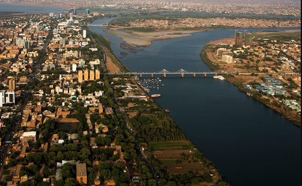
The Nile River is the most important geographical feature in Sudan and has shaped the country’s history, economy and patterns of settlement for thousands of years. Both the White Nile and the Blue Nile flow through Sudan before joining at Khartoum to form the Main Nile, which continues north into Egypt.
The Nile provides water for agriculture, drinking supplies, hydroelectric power and transportation. Major irrigation projects, including the Gezira Scheme, depend on the river system, making it essential to Sudan’s agricultural production and food security.
Cities such as Khartoum, Omdurman, Bahri, Wad Madani and Dongola developed along the Nile, reflecting its central role in Sudan’s economic and cultural life.
Climate
Sudan’s climate varies considerably from north to south. The northern part of the country is dominated by an arid desert climate, characterised by extremely low rainfall and high temperatures throughout much of the year.
Central Sudan experiences semi-arid conditions with seasonal rainfall that supports farming and livestock production. Southern regions receive higher levels of rainfall, creating more fertile agricultural land and diverse ecosystems.
Climate variability, including droughts and floods, continues to influence agriculture, water resources and rural livelihoods across different parts of Sudan.
Administrative Divisions
Sudan is administratively divided into eighteen states, each with its own capital and local government institutions.
The states are:
• Khartoum
• Gezira
• River Nile
• Northern
• Red Sea
• Kassala
• Gedaref
• Sennar
• White Nile
• Blue Nile
• North Kordofan
• South Kordofan
• West Kordofan
• North Darfur
• South Darfur
• Central Darfur
• West Darfur
• East Darfur
These states differ significantly in geography, population, economic activity and environmental conditions, reflecting Sudan’s considerable regional diversity.
Major Regions
Although Sudan is officially divided into states, several historic regions continue to play an important role in describing the country’s geography and identity.
These regions include:
• Darfur
• Kordofan
• Central Sudan
• Eastern Sudan
• Northern Sudan
• The Nile Valley
Each region possesses distinct geographical characteristics, economic activities and cultural traditions, contributing to Sudan’s rich national diversity.
Natural Resources
Sudan possesses abundant natural resources that support its economy and long-term development potential. The country is rich in fertile agricultural land, freshwater resources, livestock and mineral deposits.
Gold is Sudan’s leading mineral export, while other resources include chromium, iron ore, copper, gypsum and limestone. Sudan is also one of the world’s leading producers of gum arabic, a natural product used in the food, pharmaceutical and manufacturing industries.
The country’s extensive grazing land, forests and renewable water resources further contribute to its economic importance within the region.
Population and Demographics
Sudan is home to a diverse population representing hundreds of ethnic groups, languages and cultural traditions. Arabic is the country’s most widely spoken language and serves as the principal language of government, education and commerce, while numerous indigenous languages are spoken across different regions.
Most of Sudan’s population lives in the Nile Valley, central Sudan and major urban centres such as Khartoum, Omdurman, Port Sudan and Wad Madani. Population distribution varies considerably because of climate, water availability and economic opportunities.
Migration, urbanisation and displacement resulting from conflict have significantly influenced demographic patterns in recent decades.
Frequently Asked Questions
Where is Sudan located?
Sudan is located in northeastern Africa between North Africa, the Sahel and the Horn of Africa.
How large is Sudan?
Sudan covers approximately 1.88 million square kilometres, making it one of Africa’s largest countries.
How many states does Sudan have?
Sudan is divided into eighteen states.
What are Sudan’s major geographical regions?
The country’s major historic regions include Darfur, Kordofan, Central Sudan, Eastern Sudan, Northern Sudan and the Nile Valley.
Why is the Nile important to Sudan?
The Nile supplies water for agriculture, drinking, hydroelectric power and supports many of Sudan’s largest cities and farming projects.
Related Guides
• Darfur
• Kordofan
Sources
This guide is based on publicly available information from:
• Encyclopaedia Britannica
• CIA World Factbook
• Library of Congress – Country Studies
• United Nations Office for the Coordination of Humanitarian Affairs (OCHA)
• Food and Agriculture Organization (FAO)
• United Nations Development Programme (UNDP)
• African Development Bank (AfDB)
• Government of Sudan publications
• Academic geographic research and international reference materials.
Last Updated: 26 July 2026